
The world's largest sand island is a popular tourist destination. While the major activity on the island seems to be four wheel driving, there is some nice walking hidden away from the roads. The island is huge being 120 km long by about 14 km wide and the sand dunes tower over 240m in height. There are over 40 freshwater lakes on the island, some being perched 200m above sea level.
The northern end of the island is a National Park and provides some fine wilderness walking - that is no tracks or facilities of any type. The major difficulty of walking in the north is access is difficult to arrange as very few drive to it and there is little information on where to walk. The rangers want to keep it track free and have requested me to not write detailed track notes to the area.
The centre of the island contains the biggest site of attraction on the island and is actually more scenic than the northern end anyway. With numerous lakes, good camping areas and quiet walking tracks or closed roads, there is some excellent walking. Combine this with the easy access and you will see why the centre is the most popular walking area on the island.
There are numerous short walks. The main overnight walks are
a three day circuit based around the Central Station area and the newly
created Fraser Island Great Walk which includes most of the central
circuit plus new tracks to the the north to Happy Valley. . There are
not many hills to ascend or descend but
walking in sand can be tougher than expected and we have graded
these walks as being around medium standard. They are suitable for
begineers but can he harder to walk than expected.
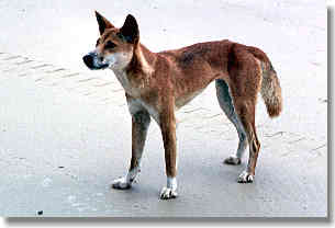
One issue on the island are the dingoes. They can be aggresive
and
have been known to tear open tents searching for food. Each campsite is
either enclosed within a dingo proof fence or has a dingo proof
enclosure for food storage. Place ALL food in a dingo proof area or
enclosure.
Fraser Island is located 250 km north of Brisbane. The main service town near the island is Hervey Bay. This was originally 3 small seaside towns that have grown together to become one long narrow town about 4 km long. The island is clearly visible from the town.
Hervey Bay is close to the main highway that runs along the
coast north from Brisbane towards Townsville and Cairns. It is
serviced by multiple numbers of buses daily from Brisbane. Access
to the island is by barges which carry vehicles or by passenger
launches - the Kingfisher Fastcat is popular with walkers. These
services several times daily. Inquire around in Hervey
Bay as prices vary between different services. On the island, Fraser Island Taxi Service
(tel 07 -
4127 9188) provides transport to track heads and a food re-supply
service (if you dont want to carry all of it).
Maps are highly variable. The detailed contour maps leave most
roads and tracks off while the Tourist Maps do not have contours
but show most roads and tracks. In practice it is wise to take
both. The SUNMAP or Hema 'Tourist Map Fraser Island' is very useful and
the NATMAP 1:100,000 Wide Bay and Happy Valley are less useful.
Detailed track notes and a topographic map of the two walks are
available from Queensland Parks and Wildlife Service (around $8)
| 1 | Eurong to Lake McKenzie, 19km |
| 2 | Past Central Station to Lake Boomanjin, 22km |
| 3 | Past Dilli Village and along beach to Eurong, 17km |
| 1 | Dilli Village to Lake Benaroon,13.5km |
| 2 |
Lake Benaroon to Lake McKenzie,
13.8km |
| 3 |
Lake McKenzie to Lake Wabby, 11.9km |
| 4 |
Lake Wabby to Valley of the Giants,
16.2km |
| 5 |
Valley of the Giants to Lake
Garawongera, 13.1km |
| 6 |
Lake Garawongera to Happy Valley,
6.6km |
None are needed for walking but a general permit to camp on Fraser Island is required ($4 per night). This can be obtained at the local council offices, by phone on 131304 or inquire with the barge services that will take you out to the island.